 Sediment Deposition on a Salt Marsh Surface |
Trine Christiansen and Patricia Wiberg
Department of Environmental Sciences
|
|
Sediment Deposition on a Salt Marsh Surface |
|
Trine Christiansen and Patricia Wiberg
Department of Environmental Sciences
|
The processes controlling sediment deposition on vegetated tidal salt marshes are not well understood, yet rates of sediment deposition are of fundamental importance to marsh ecology and hydrology. On the Atlantic coast of the United States, relative sea level is rising at a rate of approximately 2 mm per year. It is therefore important to understand the mechanisms by which marshes are maintained at an elevation that is adequate for sustaining the marsh ecology.
On the Eastern Shore of Virginia, long term deposition rates of 1-2 mm per year have been quantified using 210_Pb dating techniques, indicating that the marshes in this area are in fact accreting at a rate comparable to the rate of sea level rise. Although the marshes are depositional, the mechanisms that govern sediment deposition on these vegetated surfaces and their relative importance remain unclear.
The work presented in this study involves a description of flow and sediment transport paths on a tidal salt marsh. Here measurements and calculations are presented that will aid in investigating marsh sediment dynamics. The measurments consist of sediment concentration, current velocity, sediment grainsize distribution and water surface elevation. We will incorporate this information into a simple mathematical description of the physical processes, to aid in adressing what the dominant sediment transporting processes on the marsh surface are.
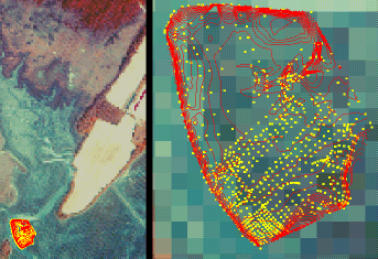
We have, for the study, selected a mainland fringing salt marsh in the Phillips Creek area near Brownsville, located on the Atlantic side of the Delmarva Peninsula on the Eastern Shore of Virginia. It was found practical to focus the work on the low salt marsh environment, because tidal flooding here occurs on a regular basis and the vegetation (short or tall form of Spartina Alterniflora) is uniform. The tidal range in this area is 1-1.5 meters. The daily flooding provides the opportunity to conduct repeated measurements and allows for a reasonable spatial resolution with one set of instruments to measure currents and suspended sediments.
Click here for FULL PAPER.