 MODELING COASTAL ECOTONE DYNAMICS |
Bruce P. Hayden
Department of Environmental Sciences
|
|
MODELING COASTAL ECOTONE DYNAMICS |
|
Bruce P. Hayden
Department of Environmental Sciences
|
MODELING COASTAL ECOTONE DYNAMICS
From metric air photographs we have charted the position of the beach strand vegetation. This vegetation is mostly American beachgrass (Ammophila breviligulata L.) The boundary between the active sand of the beach system and the grassland inland is clearly evident on the photographs. We have charted this position every 50 meters along the coast from each of seven sets of photographs for the period 1949-1985. For each 50 m location we have calculated the average rate of seaward (accretion) or landward (erosion) movement of this ecotone. We also have calculated the standard deviation of these rates of change.
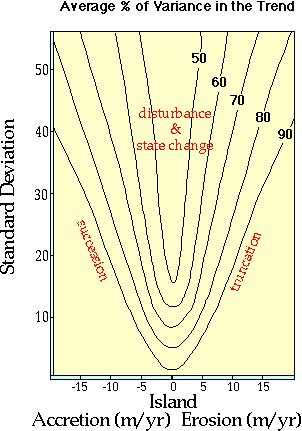
With these metrics of system dynamics we have constructed a stochastic model which generates future time histories of ecotone position. Form these realizations we have fitted a regression line. the slope of the regression line is the mean rate of change of the ecotone. We also charted the percent of variance accounted for by the regression line. Using the stochastic realization generator and the regression analysis of the model output statistics we have built a nomogram (y-axis = standard deviation; x-axis = mean rate of change of the ecotone) and within the nomogram space plotted and contoured the percent of variance in the trend of the regression of the model output data.
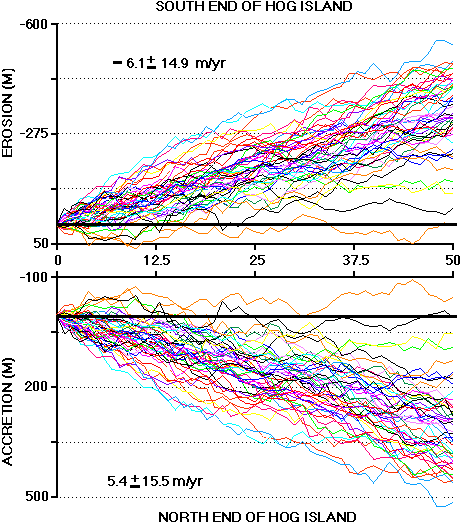
Each line represents a realization of a future 100 year history for a site on Hog Island.
This nomogram is presented below. On the nomogram we have indicated our knowledge of the nature of the dynamics of parts of the islands with the mean and standard deviations of the ecotone movements. Where the island is accreting (growing seaward) new land is built and old land goes through a succession from grassland to shrubland. In regions with rapid erosion (truncation of the island and landward displacement of the ecotone through loss at the seaward edge) landscapes are destroyed.
Where the mean rates of change of the ecotone position is are low to modest and the standard deviations are very high, landscapes disturbance (interrupted succession) and state change (change in the end of succession) are observed.
In the illustration below we have indicated where various sections of the Hog Island coast fall in the nomograms developed. The observed landscape and ecosystem dynamics of the island were used to classify the island into three reaches. Numbers were used to indicate each of the 5 reaches of the coast and these code numbers were placed on the nomogram.
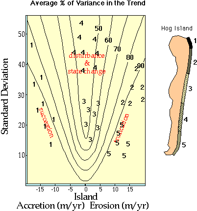
It is interesting to note that over of record that Hog Island rotates. Between 1852 and 1871 the north end of Hog Island was eroding (position 5 on the nomogram). Between 1871 and 1969 the north end accreting and would fall in position 1 on the nomogram. Since 1969 we have returned to position 5 on the nomogram. The sequence of change of position on the nomogram for the south end of the island has be the reverse. In effect these century long period punctuated by reversals in dynamics causes coastal locations to move left and right across the surface of nomogram space.
This work was presented at an ESA meeting and is being prepared for publication.