 These transects were selected because of differences in exposure
and microtopography and because J. virginiana were found in the
vicinity.
These transects were selected because of differences in exposure
and microtopography and because J. virginiana were found in the
vicinity.
For the past 2 years we have examined the salinity tolerance and small-scale
distribution patterns of Juniperus virginiana on Hog Island. To
quantify temporal and spatial levels of salinity this and other woody species
are likely to encounter on Hog Island, we examined three of the 5 LTER cross
island transects. The first transect (T1) was on the northern accreting end of
the island. A second transect (T5) was established on the southern eroding
portion of the island. The third transect (T4) was in the central portion of
the island.
These transects were selected because of differences in exposure
and microtopography and because J. virginiana were found in the
vicinity.
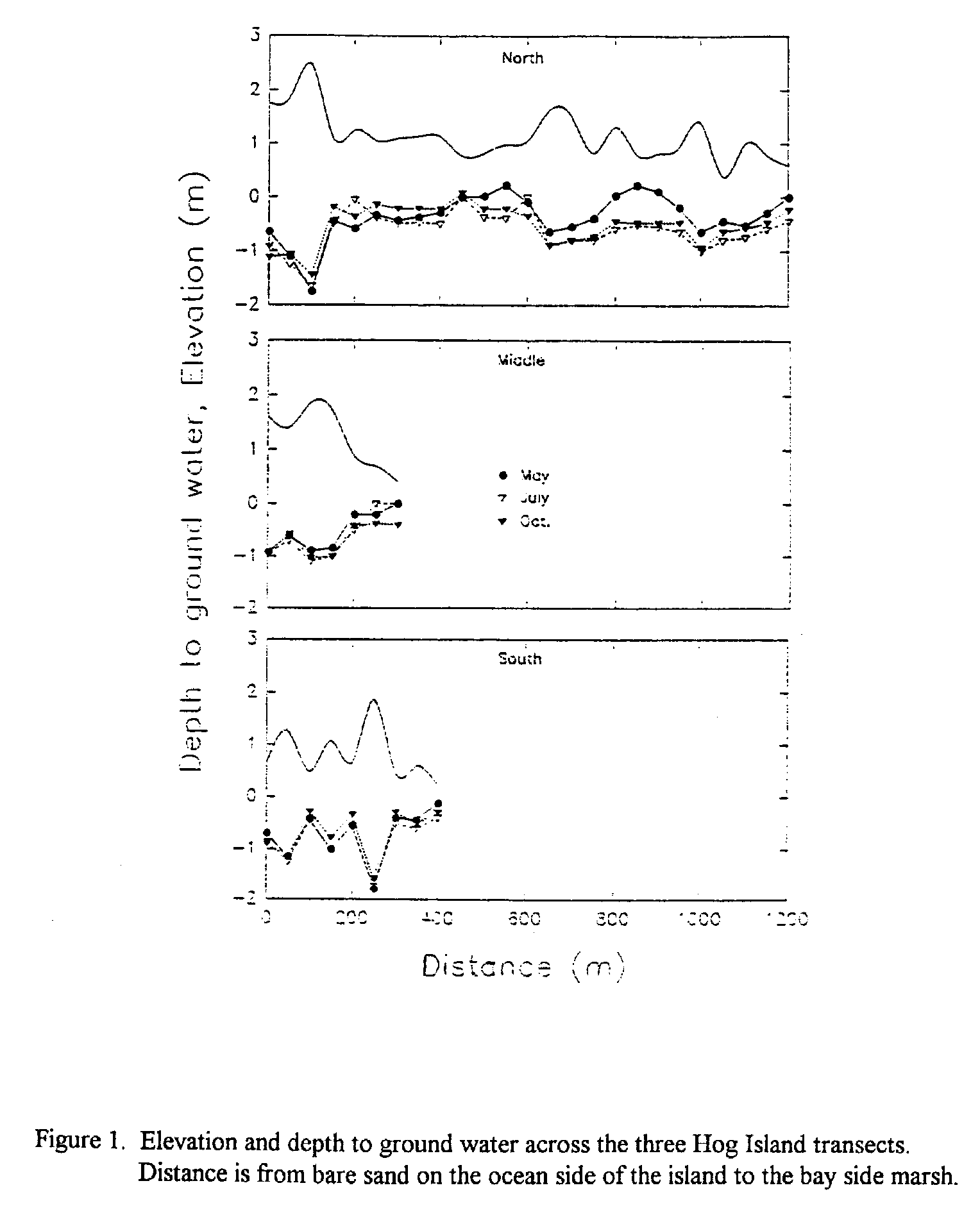
For the north transect elevation ranged from 0.38 to 2.47 m
(Fig. 1). The
highest point was the primary dune on the ocean side of the island, while the
lowest was near the jeep trail on the bay side of the island. The range
for the middle transect was from 0.41 m to 1.72 m (Fig. 1). The highest point
was in the center of the island while the lowest was in the marsh. Range for
the southern transect was 0.24 m to 1.87 m (Fig. 1). Again, the highest point
was in the center of the island, while the lowest was in the marsh. Depth to
groundwater was also variable. For the south transect median depth was -0.55 m
(Fig. 1). For the middle transect the median depth was -0.65 m (Fig. 1). The
most pronounced variation in depth to ground water was found on the north
transect, the median depth was -0.55 m (Fig. 1).
 In May there was standing
water at 5 of the well sites, while in August there was no standing water along
the transect. At the well sites located in the shrub thickets, there was a 0.5
m increase in depth between the May and September sampling. The variation in
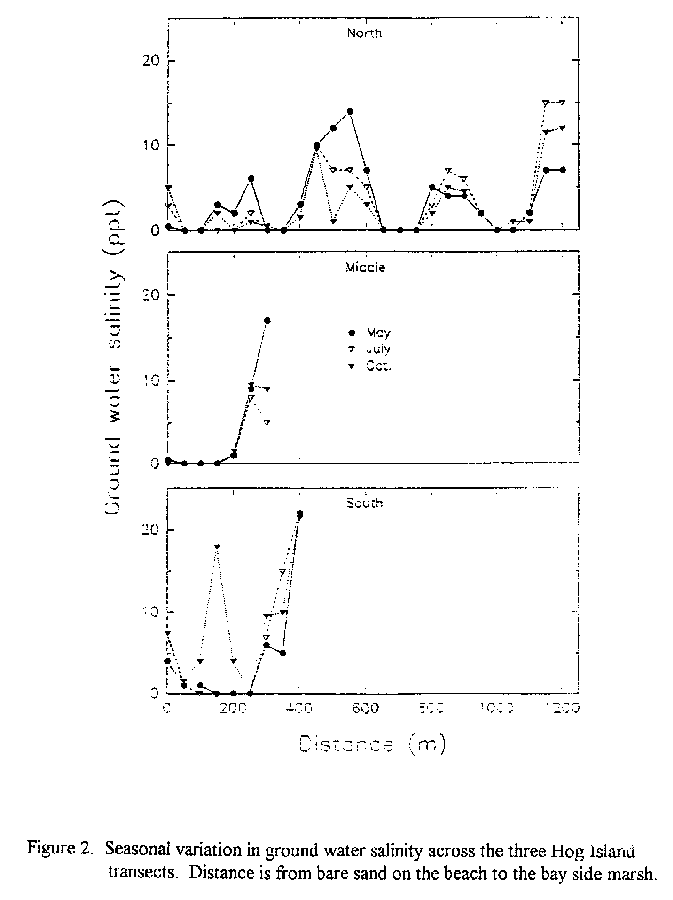
ground water salinity was also the greatest along the northern transect
(Fig.
2). The maximum range in salinity of 0 to 15 ppt. The highest level was
observed in the two ponds in the center of the island. There was little
variability in the groundwater salinity for the middle transect with the
exception of the wells in the marsh (Fig. 2). The maximum range was 0 to 17
ppt. For the south transect the range in salinity was 0 to 22 ppt (Fig. 2).
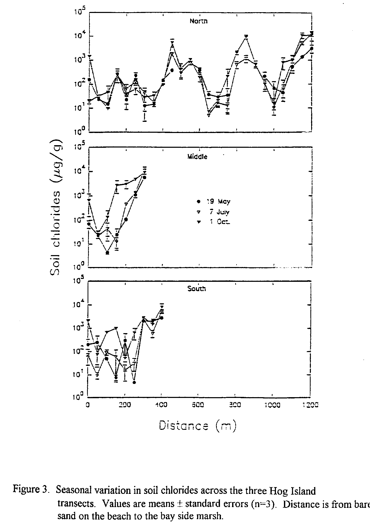
As shallow roots may be more influenced by soil salinity than ground water
salinity, we quantified soil chloride content across the transects. For all
three transects the minimum chloride level was around 5 g.g-1
(Fig. 3) .
While the highest nearly 9000 g.g-1. The highest values observed
in the marsh and for the north transect in the beds of the dried up ponds.
In May there was standing
water at 5 of the well sites, while in August there was no standing water along
the transect. At the well sites located in the shrub thickets, there was a 0.5
m increase in depth between the May and September sampling. The variation in
ground water salinity was also the greatest along the northern transect
(Fig.
2). The maximum range in salinity of 0 to 15 ppt. The highest level was
observed in the two ponds in the center of the island. There was little
variability in the groundwater salinity for the middle transect with the
exception of the wells in the marsh (Fig. 2). The maximum range was 0 to 17
ppt. For the south transect the range in salinity was 0 to 22 ppt (Fig. 2).
As shallow roots may be more influenced by soil salinity than ground water
salinity, we quantified soil chloride content across the transects. For all
three transects the minimum chloride level was around 5 g.g-1
(Fig. 3) .
While the highest nearly 9000 g.g-1. The highest values observed
in the marsh and for the north transect in the beds of the dried up ponds.
 Soil chloride contents were also determined for samples from the rhizospheres
of J. virginiana. These values ranged from 11 to about 12,000 g.g-1
with a median of 54.2 g.g-1 . Over 60% of the sites sampled on all three
transects had chloride levels that exceeded the median value observed from the
J. virginiana rhizospheres. In a comparison to woody species previously
studied on Hog Island, we found that salinity tolerance of J.
virginiana was intermediate to the halophyte Iva fructescens and the
gylcophytes Baccharis halimifolia and Myrica cerifera.
Soil chloride contents were also determined for samples from the rhizospheres
of J. virginiana. These values ranged from 11 to about 12,000 g.g-1
with a median of 54.2 g.g-1 . Over 60% of the sites sampled on all three
transects had chloride levels that exceeded the median value observed from the
J. virginiana rhizospheres. In a comparison to woody species previously
studied on Hog Island, we found that salinity tolerance of J.
virginiana was intermediate to the halophyte Iva fructescens and the
gylcophytes Baccharis halimifolia and Myrica cerifera.
Results from laboratory studies on the salinity response, in conjuction with the findings from the field, indicate that the potential distribution of J. virginiana could cover most of Hog Island. Factors other than salinity are influencing the small-scale distribution patterns currently observed.