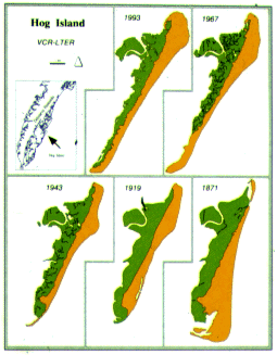
Survey measurements of Hog Island began in the middle of the 1800s and continues to the present. Today we use aircraft and satellites to aid us in measuring the shapes of the islands. At the beginning of the period of record the shoreline on the south end of Hog Island was building seaward and the north end eroding landward. By the turn of the century that pattern had reversed. The north end began to build and the south eroded. This pattern again reversed itself around 1969 and today the south end is building again and the north end eroding.