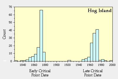
Reversal of Erosion and Accretion in the 1870s at Hog Island
Using maps produced by the Coast and Geodetic Survey (more recently NOAA) we have found that a second critical point of change occurred at Hog Island in the 1870s when there was a change from accretion to erosion along the south end of Hog Island and from erosion to accretion along the north end of the island. This is the reversal of the change that happened on Hog Island in the late 1960s.